


Brandon Wood - WML & OD Club Champs (2024)
A West Midlands League regional event suitable for everyone from the absolute beginner to the experienced orienteer.
Final Details here as a pdf (revised 01/02/25) Final detaiils updated with recent forestry work and map showing the area to avoid
Since the maps were printed at the start of December there has been forestry work in the eastern part of the area.
One linear area—adjacent to a large path—does not significantly affect courses, and it is obvious there have been recent “clearing” works. This area is likely to be encountered on Light Green and longer courses and is just to the West of control 167 on these courses.
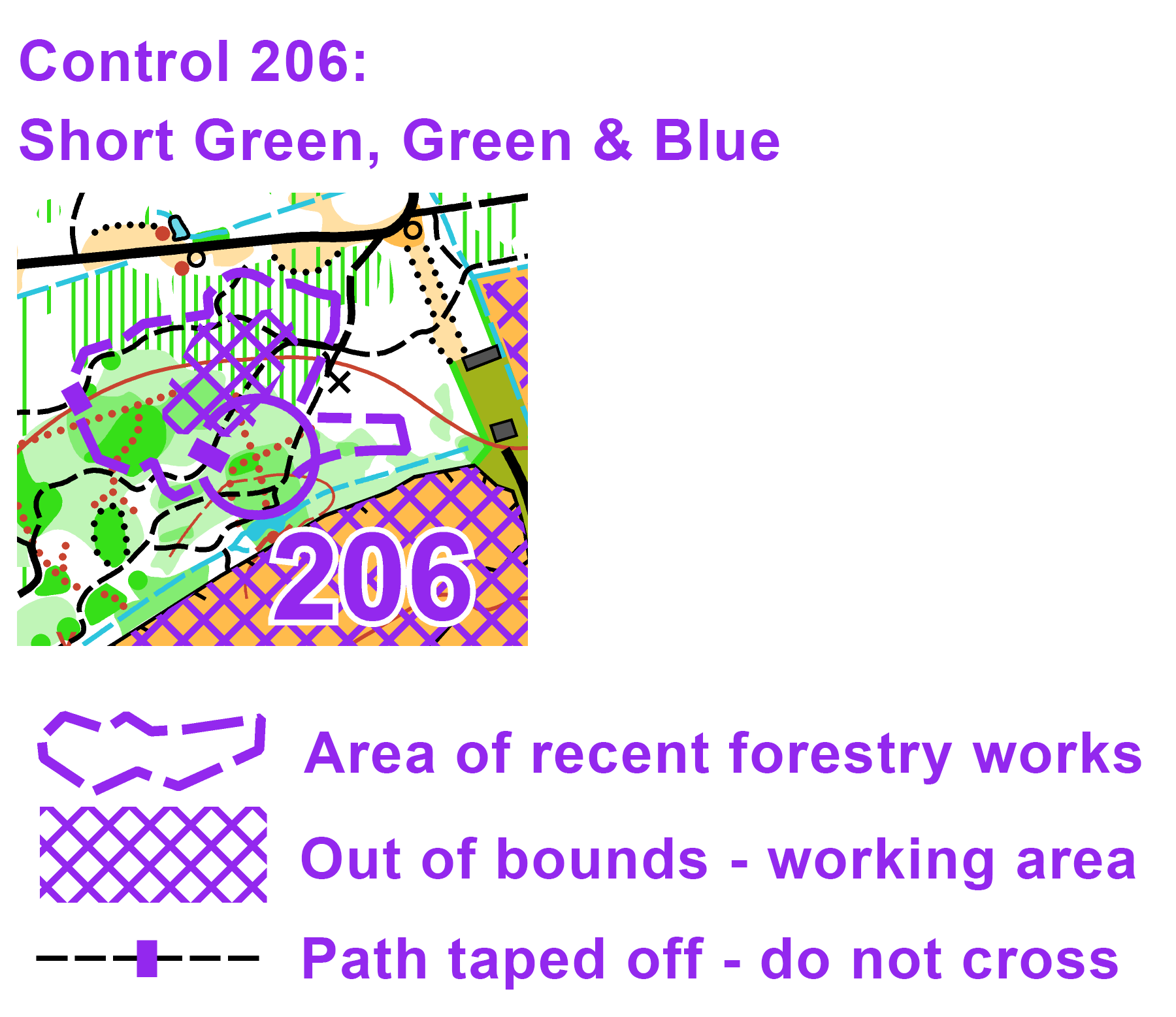
The other area – just to the North of control 206 on Short Green, Green and Blue – is more significant and there is planned work on Sunday morning. The working party will be present in the Wood from 10:00 until 13:00 using both machinery and hand tools. Some of the work can create hazards so competitors should give a wide berth. Competitors are requested to be mindful, for the sake of safety, that any instruction given by a member of the working party must be complied with. Two paths leading into the area will be taped off – do not cross these tapes if you encounter them.
For control 206, you should aim to approach the control from the S or E – it should be visible from the path - and you must avoid the OOB area to the NW of the control. A map of 206 will be displayed at the pre-start.
Location: On the southeast side of Coventry. From the A45 Coventry ring road (Stonebridge Highway), head south on the A45 towards Rugby. After about 100m, turn left after the Esso garage onto Brandon Lane. Head east on Brandon Lane for about 2km and parking is on your right, signed Brandon Marsh Nature Centre.
Car Park: Breedon Coventry Concrete Plant. Predominately hard standing car parking.
Map Reference: SP386762
Google Maps
Postcode: CV3 3GW
What3words: ///path.ideal.tamed
Enquires / Registration / Download in the assembly field about 200m from the nearest parking (500m max)
Start & Finish about 150m from the assembly field.
After some late cancellations, Light Green, Short Green, Green, Blue and Brown have a few spaces. To reserve one of these maps please email entries@octavian-droobers.org
EOD (Entry on the Day) subject to the availability of printed maps - see table below..
Senior British Orienteering member £12 (Non-Member £14)
Juniors £4 (including full-time students)
SI card hire £1 (Non SIAC)
Start times: from 10.30 to 12.30.
SI Punching: SIAC enabled. Punch the start and finish.
Courses: White, Yellow, Orange, Light Green, Short Green, Green, Blue and Brown.
Final course length, climb, controls and map availability:
| White | 1.8km | 15 m | 11 controls (pictorial & text descriptions) | 9 maps |
| Yellow | 2.2 km | 20 m | 11 controls (pictorial & text descriptions) | 12 maps |
| Orange | 2.6 km | 25 m | 11 controls (pictorial & text descriptions) | 13 maps |
| Light Green | 3.0km | 40 m | 14 controls | 5 maps |
| Short Green | 4.0 km | 50 m | 14 controls | FULL |
| Green | 5.4 km | 65 m | 18 controls | 2 maps |
| Blue | 7.3 km | 110 m | 24 controls (double-sided map) | 1 map |
| Brown | 8.8 km | 125 m | 26controls (double-sided map) | 2 maps |
Map: 1:10,000 with 5m contours on waterproof paper. ISOM 2017-2 map by Bruce Bryant with selective revisions in 2024.
Terrain: A mix of conifer plantation and ancient deciduous woodlands plus an old quarry for some of the longer courses. There are now significant areas of bramble in Brandon Wood but the majority can be avoided using the extensive network of paths and tracks.
Organiser: Viv Lawson Email: vll(at)btinternet.com
Planner: Harriet Lawson
Controller: Kirsten Mitchell (HOC).
OD Club Championships handicaps are here
COVID: Please do not come if you have symptoms of Covid-19, or suspect you may have it.
Safety and Risk:
A risk assessment will have been carried out by the organiser, but participants take part at their own risk and are responsible for their own safety during the event. If you have a high-risk medical condition you want organisers to be aware of please leave details at enquiries in a sealed envelope with your name on it. You can use this medical form. Envelopes will only be opened if required for a medical emergency. Unopened envelopes should be collected after the event. Any unclaimed envelopes will be destroyed after the event.
An emergency number for the day is printed on the map. First aid and details of the nearest A&E hospital will be available in the assembly area.
Photography:
British Orienteering has an agreed national guidance policy on the taking of photographs at events. If you are unsure about the agreed acceptable practice, please speak to the event organiser.
Privacy & Personal Data:
When entering events your personal details (name, age, gender, club) will appear in the results section on this website. It may also be used to trace missing runners and hired SI cards.
Map
List of Dates (Page event details)
- Sun, 02 Feb 2025 10:30
Powered by iCagenda