


Burton Dassett Hills - OD Local League Score event
An OD Local League Score event at Burton Dassett country park, suitable for everyone from the absolute beginner (help and advice available) to the experienced orienteer.
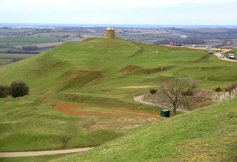
Terrain: Burton Dassett country park is a hilly mainly open area with small areas of woodland. The top of the country park is an old mining area with complex contour detail. There are Nettles and thistles in places (although I have tried to avoid the worst) so leg covering is suggested.
Location : CV47 2AB, between Banbury and Leamington Spa and a few km south of Jn 12 on the M40. From the M40 Jn 12 head weat and then follow the brown signs to Burton Dassett Country Park. In the country park follow orienteering signage.
OS grid reference: SP 395 521 What3Words: ///neckline.effort.fight
Car parking: £3.30.- Card payment only
Start times: 18:30 - 19:30 Courses close at 20:15
Punching: SI - SIAC enabled. Punch the start and finish.
NO EOD (Entry on the Day). All printed maps are reserved.
45 minute Score course:.
Rules:
This is a 45 minute Odds and Evens score event so you will have 45 minutes to visit as many controls as possible.
Visit Odds first which are worth 10 points each, at any time return to control number 240 and then turn over to Evens which are worth 20 points each. Minus 20 points for every minute (or part minute) over 45 minutes.
A full explanation will be given on the day, it’s not as complicated as it sounds but will need judgment to decide how many Odds to visit before turning over if you are not going for them all.
The optimal straight line distance is around 5.1km but expect to run longer and the hills at Burton Dassett can slow you down a lot.
Map: 1:5000 (ISSprOM 2019-2) with 2m contours to help show the complex details in the centre of the area. Control descriptions are printed on the map (no loose descriptions).
Toilets: The county park toilets are approx 300m from the car parking area but when last visited they were closed up and it is not known if they will be open on the day (unlikely).
Enquiries / Registration / Download: in the car park with the Start and Finish adjacent
Dogs: On lead only, there are grazing sheep in the country park
Other notes:
The area is generally open and runnable with complex contour detail however there are small nettle patches which are easily avoidable and larger areas of thistles - not mapped - which do not impede running significantly.
Due to extensive public use and 4X4 activity on the terrain, some paths are not mapped. Some mapped paths have become indistinct.
A minor road runs through the park as well as various car park access roads. Take care crossing these roads when competing but also be aware of orienteers when entering and leaving the event.
Note the out of bounds area - to competitors - in the centre of the map and the special symbols marked on the map.
The area is well used by the public, please show consideration to other users of the country park.
Suggestion for a pint/meal afterwards
The Lost Pug in Northend at the bottom of the hill
Bottom Street , Northend , CV47 2TJ
https://thelostpug.com
Safety and Risk:
There is a single track road going through the park which will need to be crossed. It is quiet and traffic is generally slow but younger juniors will need to be supervised by parents.
Once you have started a course it is a rule that you don't leave the event without reporting to a download official even if you retire.
A risk assessment will have been carried out by the organiser, but participants take part at their own risk and are responsible for their own safety during the event. It is recommended that whistles are carried. If you have a high risk medical condition you want organisers to be aware of please leave details at enquiries in a sealed envelope with your name on it. can use this medical form. Envelopes will only be opened if required for a medical emergency. Unopened envelopes should be collected after the event. Any unclaimed envelopes will be destroyed after the event.
An emergency number for the day is printed on the map. First aid and details of the nearest A&E hospital will be available in the assembly area.
Photography:
British Orienteering has an agreed national guidance policy on the taking of photographs at events. If you are unsure about agreed acceptable practise please speak to the event organiser.
Privacy & Personal Data:
When entering events your personal details (name, age, gender, club) will appear in the results section on this website. It may also be used to trace missing runners and hired SI cards.
COVID: Please do not come if you have symptoms of Covid-19, or suspect you may have it.
Planner: - Mark Rookledge
Map
List of Dates (Page event details)
- Wed, 03 Jul 2024 18:30
Powered by iCagenda